
For the weary traveler on I-5, the world often narrows to a ribbon of gray asphalt, the rhythmic thrum of tires, and the blurred green of the Willamette or Rogue Valleys flashing past at seventy miles per hour. It is a corridor of efficiency, a means to an end. But between the cities of Roseburg and Medford, there exists a portal to a different Oregon-one where time is measured by the slow drip of ancient springs and the thunderous collapse of glacial melt over basalt cliffs.
The Rogue-Umpqua Scenic Byway, affectionately known as the “Highway of Waterfalls,” is more than just a scenic drive; it is a 172-mile sensory immersion. Here, the air carries the scent of damp cedar and cold stone. The roar of the interstate is replaced by the polyphonic symphony of two of America’s most storied rivers: the North Umpqua and the Upper Rogue. To turn off the I-5 and onto this loop is to step into a landscape that feels primordial, a place where the volcanic bones of the Cascade Range are draped in velvet moss and emerald ferns.
Whether you are seeking a few hours of respite or a multi-day odyssey, this route offers a profound connection to the wild heart of the Pacific Northwest.
Fast Facts for the Road
Before you turn the ignition and leave the valley floor behind, here is the essential data for your journey on the Rogue-Umpqua Scenic Byway:
- Total Mileage: Approximately 172 miles (277 km) from Roseburg to Gold Hill.
- Recommended Travel Time: A minimum of 5 to 7 hours for a straight drive with brief stops. To truly experience the falls and trails, 2 to 3 days is ideal.
- Best Time to Visit: Late spring (May-June) for peak waterfall volume, or autumn (October) for brilliant vine maple colors and thinning crowds.
- Highest Point: The North Umpqua/Rogue divide near Diamond Lake (approx. 5,100 feet).
The Route: A Geographic Walkthrough
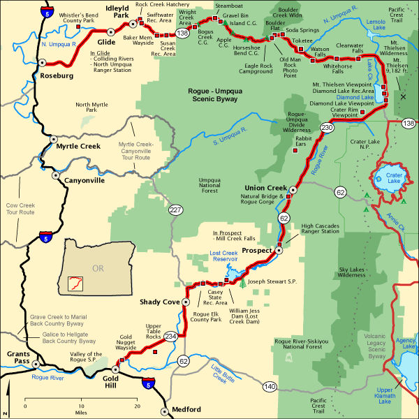
The Gateway: Roseburg and the North Umpqua
The journey on the Rogue-Umpqua Scenic Byway begins in Roseburg, where the rolling oak-dotted hills of the Umpqua Valley begin to tighten into a steep-walled canyon. As you head east on Highway 138, the North Umpqua River becomes your constant companion. This is a “blue-ribbon” fly-fishing stream, legendary among anglers for its elusive steelhead.
Your first mandatory stop is Steamboat. This isn’t a town so much as a feeling. The historic Steamboat Inn sits perched over the river, a sanctuary of hand-hewn beams and world-class hospitality. Even if you aren’t staying the night, stop to walk across the nearby suspension bridges. Feel the vibration of the water beneath your boots; the river here is a translucent teal, swirling around ancient boulders with a relentless, rhythmic grace.
The Cathedral of Basalt: Toketee Falls
As you climb higher into the Umpqua National Forest, the geology becomes more dramatic. The “must-see” crown jewel is Toketee Falls. A short, half-mile trail winds through old-growth Douglas fir to a viewing platform that feels like a natural cathedral.
Toketee (a Chinook word meaning “graceful”) drops 113 feet over a wall of columnar basalt. These vertical stone pillars look like the pipes of a massive organ, carved by volcanic cooling millions of years ago. The water plunges into a deep, obsidian-colored pool, framed by vibrant green moss that thrives in the perpetual mist. The sound here isn’t just noise; it’s a physical presence that vibrates in your chest.
The Giants: Watson Falls and Diamond Lake
A few miles further, the landscape demands you look up. Watson Falls is the highest waterfall in Southwest Oregon, tumbling a staggering 272 feet. The mist from the falls creates its own microclimate, cooling the air by ten degrees as you approach the base. It is a place of sheer verticality, where the water turns to white lace against the dark rock.
From here, the road crests at Diamond Lake, nestled between the jagged spires of Mt. Thielsen (the “Lightning Rod of the Cascades”) and the massive shield of Mt. Bailey. In the summer, the lake is a mirror for the peaks; in the winter, it is a silent, snow-choked wilderness. This is the halfway point of the byway and the perfect place to pause and breathe in the thin, pine-scented air of the high Cascades.
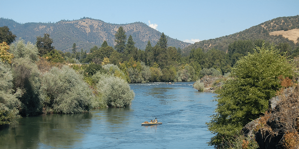
The Rogue’s Fury: Rogue River Gorge
Descending south toward the Medford area, the character of the water changes. You are now following the Upper Rogue River. At the Rogue River Gorge, the entire volume of the river is forced through a narrow chasm of black lava rock. The water here is violent and white, churning with a ferocity that illustrates the raw power of erosion.
Just downstream, visit the Natural Bridge. Here, the Rogue River disappears entirely into an underground lava tube, only to reappear several hundred feet later in a calm, sapphire pool. It is a disappearing act performed by nature, a reminder of the porous, volcanic “Swiss cheese” landscape that lies beneath your tires.
The Avenue of the Giant Boulders: Prospect
The final leg takes you through the historic timber town of Prospect. Make time for the Avenue of the Giant Boulders, where the river has tossed house-sized rocks around like marbles. The nearby Mill Creek and Barr Creek Falls offer a final, breathtaking twin-viewing opportunity, dropping hundreds of feet into the Rogue River canyon before the road finally levels out and returns you to the golden grasses of the Rogue Valley and the waiting lanes of I-5.
Hidden Gems: The Local Secrets
While the major falls are well-signed, the true magic of the Rogue-Umpqua Scenic Byway often lies in the shadows.
- Grotto Falls: Located on a forest service road near the town of Glide, this is a local favorite. Unlike the crowded platforms of Toketee, Grotto Falls allows you to walk directly behind the curtain of water. Standing in the damp, cool alcove behind the falls, watching the world through a shimmering veil of mountain water, is a spiritual experience that most travelers miss.
- Boundary Springs: This is the literal birthplace of the Rogue River. A moderate hike near the north entrance of Crater Lake National Park leads you to a spot where the river doesn’t start as a trickle, but bursts fully formed from the side of a hill. It is a pristine, silent place where the water is so pure it looks like liquid glass.
Practical Tips for the Modern Explorer
The Rogue-Umpqua Scenic Byway is a wild corridor, and it demands respect. To ensure your detour remains a highlight of your trip, keep these practicalities in mind:
- Fuel and Provisions: Fill your tank in Roseburg or Medford/Central Point. There are very few gas stations along the 172-mile stretch. While you can find fuel at Diamond Lake Resort or the small store in Prospect, prices are higher and hours are seasonal.
- Road Conditions: This is a mountain route. Expect steep grades, sharp “hairpin” turns, and potential rockfall. In the winter (November through April), the high-elevation sections near Diamond Lake require snow tires or chains. Always check [TripCheck.com](https://www.tripcheck.com) before heading out.
- Vehicle Recommendations: While the entire byway is paved and accessible to standard passenger cars and RVs, ensure your brakes are in good condition for the long descents. If you are driving a large motorhome, be mindful of narrow shoulders and limited pull-out space at some of the smaller waterfall trailheads.
- Connectivity: Cell service is non-existent for about 60% of this drive. Download your maps offline or carry a physical gazetteer. Embrace the silence; it’s part of the charm.
- Packing: Even in mid-July, the mist from the waterfalls can be chilly. Bring a light, waterproof jacket and sturdy shoes with good grip-the trails near the falls are perpetually damp and can be slippery.
Conclusion: The Long Way Home
As you merge back onto the interstate, the transition can feel jarring. The hum of the tires returns, and the pace of the world accelerates once more. But something has changed. The scent of the hemlocks still lingers in your car, and the sound of the Rogue’s fury still echoes in the back of your mind.
The Rogue-Umpqua Scenic Byway is not just a detour; it is a reminder that the most beautiful parts of life are often found when we agree to slow down. It is a journey through the plumbing of the Earth, where water and stone have been locked in a beautiful, million-year dance. For the I-5 traveler, it is the ultimate “scenic route”-a chance to trade the frantic energy of the highway for the timeless, restorative power of the Oregon wilderness.
Next time you see the sign for Highway 138, don’t just drive past. Turn the wheel. The waterfalls are waiting.
The I-5 Exit Guide is the Internet’s largest and most complete website dedicated to Interstate 5 travelers. Find detailed exit service listings… lodging, camping, food, gas and more for every exit from Washington to California!
On the road? Why not take us with you. The I-5 Exit Guide is mobile-friendly and totally FREE. No App Required.
Traveling another route? Visit our growing family of exit guides: I-4 Exit Guide, I-5 Exit Guide, I-10 Exit Guide, I-75 Exit Guide, I-80 Exit Guide and I-95 Exit Guide. Detailed exit service listings… discount lodging, camping, food, gas and more for every exit along the way!


