
For those of us tethered to the I-5 corridor, life often feels like a series of vertical movements. We drift between the tech hubs of Seattle and the industrial pulse of Tacoma, rarely glancing anywhere but the brake lights ahead. But there is a geographic pressure valve just east of the city-a 100-mile ribbon of asphalt that cuts a jagged, glorious line through the heart of the Pacific Northwest.
The Mountains to Sound Greenway is not just a stretch of Interstate 90; it is a transition through three distinct worlds. It begins with the salt-spray tang of the Puget Sound, surges through the emerald cathedral of the Cascade Mountains, and spills out into the sun-drenched, golden sagebrush of Central Washington. It is a drive where the air changes three times in two hours-from heavy and humid to crisp and pine-scented, finally becoming dry and smelling of baked earth.
If you are an I-5 traveler looking to swap the concrete jungle for a landscape that roars with life, this is your escape hatch. Grab a coffee, roll down the windows, and prepare for a transition that feels less like a commute and more like a rebirth.
Fast Facts for the Road
- Total Mileage: Approximately 100 miles (Seattle to Thorp).
- Recommended Travel Time: 2 hours for a direct blast; 2 to 3 days for a full immersion.
- Best Time of Year:
- July-September: For high-country hiking and alpine lakes.
- October: For brilliant vine maple colors and “Twin Peaks” vibes.
- January-March: For world-class skiing and snowshoeing at the summit.
- Primary Route: Interstate 90 Eastbound.
The Route: A Geographic Walkthrough
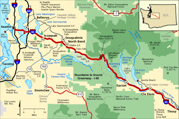
The Gateway: Seattle to Issaquah
Your journey begins at the massive interchange where I-5 meets I-90. As you head east, you immediately leave the city’s shadow by crossing the Homer M. Hadley Memorial Bridge-the fifth-longest floating bridge in the world. Feel the car lift as you glide over the deep blue of Lake Washington. To your left, the Seattle skyline glints; to your right, the snow-capped peak of Mount Rainier often looms like a silent sentinel.
Within fifteen minutes, the suburban sprawl of Bellevue gives way to the “Issaquah Alps.” This is where the green begins to tighten its grip on the road. Stop in Issaquah at the Chittenden Locks’ smaller cousin, the Issaquah Salmon Hatchery, to see the primal struggle of Coho and Chinook salmon returning home. If you’re feeling adventurous, look up at Poo Poo Point on Tiger Mountain; on a clear day, the sky is speckled with the colorful sails of paragliders catching the thermals.
The Monolith: North Bend and Mount Si
Leaving Issaquah, the valley narrows and the peaks sharpen. You are now entering the realm of the “Twin Peaks” fans. The town of North Bend sits in the literal shadow of Mount Si, a massive block of metamorphic rock that rises 4,000 feet from the valley floor.
Even if you aren’t an avid hiker, pull over at the Snoqualmie Valley Trail or take the short detour to Snoqualmie Falls. Standing on the observation deck, you’ll feel the mist on your skin and hear the thunder of 270 feet of roaring white water. It is a sensory overload that reminds you exactly why this region is defined by its water. Back in town, grab a slice of cherry pie at Twede’s Cafe-the neon sign and the smell of fresh coffee are pure Americana.
The Ascent: Snoqualmie Pass
This is the heart of the Greenway. As I-90 begins its steep climb toward the clouds, the Douglas firs grow taller and the air turns noticeably cooler. The road here is an engineering marvel, carved into the granite cliffs. Keep an eye out for the Price Creek Wildlife Overpass-a massive, vegetated bridge designed specifically for elk, bears, and cougars to cross the freeway safely.
At the Summit at Snoqualmie, you reach the crest of the Cascades. At 3,022 feet, you are at the tipping point of the state. In winter, this is a neon-lit playground of skiers and snowboarders. In summer, it’s the gateway to the Pacific Crest Trail (PCT). Park at the Alpental lot and take a short walk; within ten minutes, the sound of the freeway vanishes, replaced by the whistle of marmots and the rustle of subalpine meadows.
The Rain Shadow: Cle Elum to Roslyn
As you descend the eastern slope, the transformation is jarring. The dense, dripping forests of the west side give way to the open, park-like stands of Ponderosa Pine. The “Rain Shadow” effect is in full force here; the clouds often snag on the peaks behind you, leaving the sky ahead a brilliant, piercing blue.
Take the exit for Roslyn, a historic coal-mining town that feels frozen in the late 19th century. The town’s wooden storefronts and the iconic “Roslyn Cafe” mural are famous, but the real soul of the place is found at The Brick Saloon, Washington’s oldest continuously operating bar, complete with a running water spittoon at the base of the bar.
The Valley Floor: Thorp and the Yakima River
The final leg of the Greenway takes you into the high desert. The trees thin out entirely, replaced by rolling hills of gold and the shimmering ribbon of the Yakima River. The drive concludes near Thorp, where the Thorp Fruit & Antique Mall serves as the ultimate roadside stop. The smell here is incredible-a mix of sun-dried grass and crates of fresh Peaches, Walla Walla onions, and Yakima apples. You have officially transitioned from the Pacific coast to the Inland Empire.
Hidden Gems: The Local Secrets
While the main stops are iconic, the Greenway hides secrets that most travelers bypass in their rush to reach the desert or the city.
The Middle Fork Snoqualmie River Valley:
Just outside North Bend, tucked away from the I-90 corridor, lies the Middle Fork Road. Recently paved, this road snakes deep into a “wild” valley that feels like a mini-Alaska. There are no stores, no cell service-just pristine river access, granite spires like Garfield Mountain, and the lush, mossy silence of an ancient rainforest. It is the best place to find solitude within an hour of Seattle.
Gold Creek Pond:
Located just east of the Snoqualmie Pass summit, this is a “hidden in plain sight” gem. An easy, ADA-accessible loop trail circles a crystal-clear turquoise pond that reflects the surrounding jagged peaks like a mirror. It’s the perfect spot for a picnic where you can see the “Alps of Washington” without having to climb them.
Practical Tips for the Drive
1. Fuel and Supplies:
Gas is generally cheaper in North Bend and Cle Elum than it is in the heart of Seattle or at the pass summit. If you are driving an electric vehicle, the summit and Cle Elum have seen a significant increase in fast-charging stations, making this a very EV-friendly mountain pass.
2. Road Conditions and the “Pass Report”:
Snoqualmie Pass is the lifeline of Washington commerce, but it is also a mountain environment. In winter (November-April), Washington law requires you to carry tire chains, even if you have AWD. Always check the WSDOT (Washington State Department of Transportation) website or app before you leave. Spin-outs or avalanche control can close the road for hours with little warning.
3. Steep Grades:
If you are towing a trailer or driving a heavy RV, be mindful of the descent from the summit toward Cle Elum. Use your engine braking to avoid overheating your brakes. The “Eastbound Descent” is long and can be taxing on older vehicles.
4. The “Greenway” Ethos:
Remember that this land is a patchwork of public and private holdings managed by the Mountains to Sound Greenway Trust. Many trailheads require a Discover Pass or a Northwest Forest Pass. Keep a digital or physical copy in your glove box to avoid the ubiquitous orange envelopes on your windshield.
Conclusion: The Road That Breathes
The Mountains to Sound Greenway is more than a transit corridor; it is a testament to the wild spirit of the Pacific Northwest. For the I-5 traveler, it offers a chance to break the north-south monotony and experience the sheer geographic diversity of Washington State.
It is a route that rewards the curious. It’s in the way the mist clings to the trees in North Bend, the way the sun hits the basalt cliffs near Vantage, and the way the Yakima River sparkles as it winds through the canyon. Whether you have an afternoon or a long weekend, turn off the cruise control, exit the interstate, and let the Greenway show you the soul of the Cascades. From the salt of the Sound to the sage of the valley, this is one drive that will stay in your rearview mirror long after the journey ends.
The I-5 Exit Guide is the Internet’s largest and most complete website dedicated to Interstate 5 travelers. Find detailed exit service listings… lodging, camping, food, gas and more for every exit from Washington to California!
On the road? Why not take us with you. The I-5 Exit Guide is mobile-friendly and totally FREE. No App Required.
Traveling another route? Visit our growing family of exit guides: I-4 Exit Guide, I-5 Exit Guide, I-10 Exit Guide, I-75 Exit Guide, I-80 Exit Guide and I-95 Exit Guide. Detailed exit service listings… discount lodging, camping, food, gas and more for every exit along the way!


