For most travelers on the I-5 corridor, “Washington scenery” is a predictable, albeit beautiful, palette: the deep emerald of Douglas firs, the slate gray of a drizzle-soaked afternoon, and the jagged, snow-capped silhouettes of the Cascades. We are a people of the forest and the sound. But there is a secret hiding just a few hours east-a landscape so visceral, so ancient, and so starkly different from the Puget Sound that it feels like crossing a border into another dimension.
Welcome to the Coulee Corridor Scenic Byway.
As you crest the final ridge of the Cascade Range and descend into the rain shadow, the air thins and dries. The scent of damp cedar is replaced by the spicy, intoxicating aroma of sun-baked sagebrush. Here, the earth isn’t covered in a blanket of green; it is exposed, raw, and scarred by the most cataclysmic floods in Earth’s history. This isn’t just a road trip; it’s a journey through a prehistoric battlefield where ice, water, and basalt fought for supremacy.
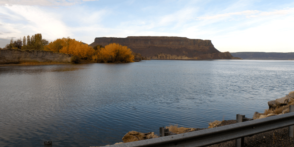
If you are tired of the stop-and-go grind of the interstate, the Coulee Corridor offers a high-octane shot of geological adrenaline. It is a land of “coulees”-giant, dry canyon walls carved by the Ice Age Floods-shimmering blue lakes, and engineering marvels that once powered the nation’s dreams.
Fast Facts for the Road
Before you trade the freeway for the canyon floor, here is what you need to know:
- Total Mileage: Approximately 150 miles (stretching from Omak in the north to Othello in the south).
- Recommended Travel Time: While you can drive it in 3.5 hours, give yourself 2 full days to truly explore the state parks and vistas.
- Best Time of Year: Late Spring (May-June) for wildflowers and manageable temperatures, or Early Autumn (September-October) for crisp air and golden light. Summers are spectacular but can frequently soar above 100°F.
- The Route: Primarily follows WA-155 and WA-17.
The Route & Main Stops: A Geographic Walkthrough
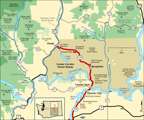
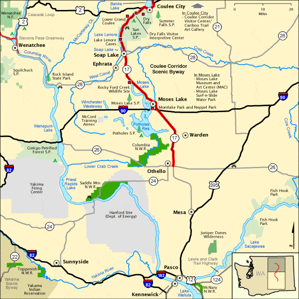
For the I-5 traveler, the best way to experience this byway is to head east on I-90, cross the Columbia River at Vantage, and pivot north at Moses Lake or Othello. As you turn onto the corridor, the horizon expands, and the scale of the landscape begins to dwarf your vehicle.
The Potholes & Othello: The Gateway of Water and Wings
Starting at the southern terminus near Othello, you enter a surreal landscape of “potholes”-thousands of small depressions left behind by the retreating floods, now filled with water.
Potholes State Park is a labyrinth of blue water and basalt islands. If you’re a kayaker, this is your playground. The sound here is a symphony of bird calls; this area is a critical stop on the Pacific Flyway. In the spring, you’ll hear the prehistoric bugling of Sandhill Cranes, a sound that echoes off the basalt cliffs and reminds you that you’ve left the modern world far behind.
Soap Lake: The Healing Waters
Driving north on Highway 17, you’ll encounter Soap Lake. For a century, travelers have flocked here for the lake’s unique mineral content-it has one of the highest diverse mineral counts of any body of water on the planet.
Pull over and walk to the shoreline. You’ll notice a peculiar sight: naturally occurring foam sudsing up against the shore, giving the lake its name. The water feels oily or “soapy” to the touch, a result of the rich minerals. In the 1920s, this was a world-renowned spa destination. Today, it remains a quirky, reflective stop where the mud is said to heal what ails you.
Dry Falls: The Niagara That Was
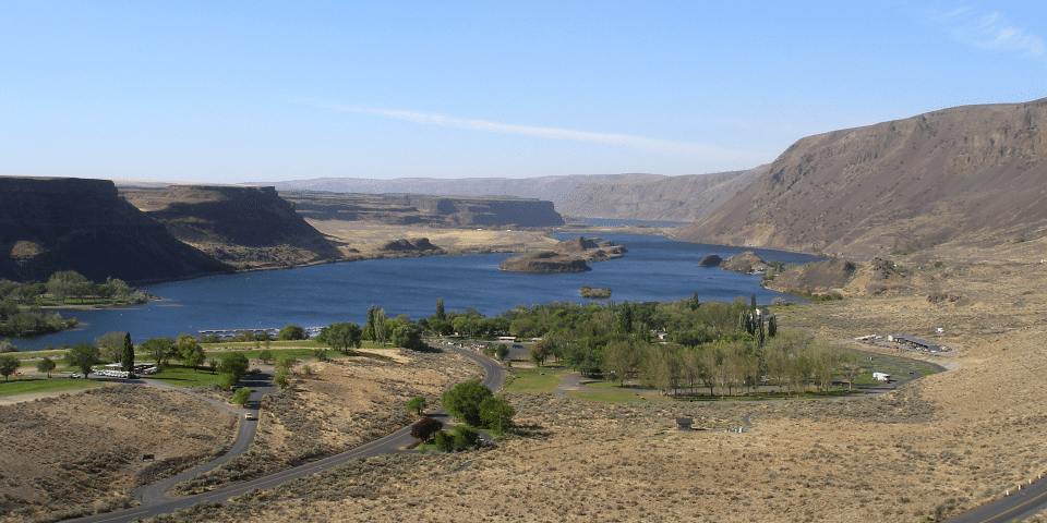
If you only make one stop, let it be Sun Lakes-Dry Falls State Park. Stand at the overlook and try to wrap your mind around the scale. During the height of the Missoula Floods, a wall of water ten times the size of all the rivers in the world combined roared over these cliffs.
At 3.5 miles wide and 400 feet high, Dry Falls is nearly three times the size of Niagara Falls. Today, it is bone-dry, a haunting skeleton of a waterfall. The silence at the overlook is profound, broken only by the wind whistling through the coulee. The sheer red-and-brown basalt walls drop vertically into deep blue plunge-pool lakes below, creating a visual contrast that will make your camera lens work overtime.
Steamboat Rock: The Monolith of the Desert
As you continue north on WA-155, a massive, flat-topped island of basalt rises out of the middle of Banks Lake. This is Steamboat Rock. Covering over 600 acres on its summit, this giant plateau was once an island in the middle of the prehistoric floodwaters.
For the adventurous, the hike to the top is non-negotiable. It’s a steep scramble, but once you reach the plateau, the world opens up. You’ll find yourself standing in a meadow of waving grass, surrounded by 360-degree views of the Grand Coulee. To the west, the blue expanse of Banks Lake; to the east, the rugged scablands. It feels like standing on the bridge of a massive stone ship navigating a sea of sagebrush.
Grand Coulee Dam: The Colossus
The byway reaches its crescendo at the Grand Coulee Dam. Even in a state defined by massive infrastructure, this dam is staggering. It is the largest power producer in the United States and one of the largest concrete structures in the world.
Take the guided tour to see the “Third Power Plant” or, if you’re staying overnight in the summer, catch the “One River, Many Voices” laser light show. Seeing the history of the Columbia River projected onto the massive face of the dam in a riot of color and sound is a quintessential Washington experience that every I-5 resident should see at least once.
Hidden Gems: Where the Locals Go
While the main stops are breathtaking, the true soul of the Coulee Corridor lies in the places that don’t have massive signs.
The North Fork of Lower Crab Creek
Tucked away near the southern end of the corridor, this area is a rugged paradise for hikers who hate crowds. It’s a wild, untamed stretch of riparian habitat cutting through the desert. Here, you can find hidden waterfalls that only flow in the spring and see basalt columns that look like organ pipes frozen in stone. It’s the perfect place to experience the “Scablands” in their rawest form.
Crown Point Vista
Most tourists stop at the Dam’s visitor center and call it a day. For the “local” view, drive up to Crown Point. This overlook sits high above the town of Coulee Dam. From here, you can see the entire arc of the dam, the beginning of the Grand Coulee, and the winding path of the Columbia River heading north. At sunset, the basalt cliffs glow like embers, and the lights of the dam begin to twinkle like a fallen constellation.
Practical Tips for the High Desert
Driving the Coulee Corridor is a different beast than navigating the I-5. You need to be prepared for the elements and the distances.
- Fuel Up: Gas stations can be 30 to 50 miles apart once you get into the heart of the coulees. Don’t let your tank drop below a quarter. Othello, Soap Lake, and Grand Coulee are your primary hubs.
- Cell Service: Expect “dead zones.” The deep basalt canyons are excellent at blocking signals. Download your maps for offline use before you leave home.
- Vehicle Check: While the roads are well-paved, the summer heat can be brutal on tires and cooling systems. Ensure your AC is in top shape. If you plan on exploring the gravel backroads near the Potholes, a vehicle with decent clearance is recommended.
- Hydration: This is a desert. Even if it’s not “hot,” the low humidity will dehydrate you quickly. Carry a gallon of water per person in the car.
- Watch for Wildlife: Deer and elk are extremely active at dawn and dusk. In the southern sections, keep an eye out for Western Rattlesnakes if you’re hiking-they generally keep to themselves, but they appreciate a respectful distance.
Conclusion: The Echo of the Floods
The Coulee Corridor is more than just a scenic drive; it is a humbling encounter with the power of nature. On the I-5, we are often shielded from the landscape by sound walls and dense foliage. But out here, in the heart of the Washington Scablands, the earth is stripped bare. You can see every layer of lava flow, every scar from the rushing floods, and every triumph of human engineering.
It is a place of dramatic contrasts: the heat of the desert vs. the cold of the deep lakes; the ancient stillness of the basalt vs. the modern hum of the dam; the brown of the sagebrush vs. the neon blue of the sky.
So, the next time the gray skies of Western Washington feel a little too heavy, pack your bags, head east, and let the Coulee Corridor remind you that you live in one of the most geologically spectacular places on Earth. The desert is calling, and its story is written in the stone.
The I-5 Exit Guide is the Internet’s largest and most complete website dedicated to Interstate 5 travelers. Find detailed exit service listings… lodging, camping, food, gas and more for every exit from Washington to California!
On the road? Why not take us with you. The I-5 Exit Guide is mobile-friendly and totally FREE. No App Required.
Traveling another route? Visit our growing family of exit guides: I-4 Exit Guide, I-5 Exit Guide, I-10 Exit Guide, I-75 Exit Guide, I-80 Exit Guide and I-95 Exit Guide. Detailed exit service listings… discount lodging, camping, food, gas and more for every exit along the way!